Author: snailcycle

“Training”

rainbow Conwy Valley

As the ride gets closer we are starting to think how our legs will go cycling every day so take every opportunity to get out on the bikes

We went to Wales for a family get together over Easter, it deluged but we managed to get out on a couple of days- essential after too much eating, riding around the West side of Conwy Valley- they have very steep hills! The steepest was 20%, we have to admit to pushing up hill at one stage but the rest of the ride was fantastic with views over to the snow still lying on the higher mountains

Martin was out with the Spire club again yesterday- good training except that there are always a couple of cafe stops- including lunch at the legendary cyclists cafe at Cromford- glad that it has resurfaced after a change of ownership

Continue Reading

Lots of people helping…

As we are making more preparations for the trip we are learning new skills- I have been using a free version of Serif publishing software from a computer magazine to create posters and some postcards- like all software there is a learning curve

One thing that strikes us is the generosity and goodwill  of local people and businesses- today I went into a great local printshop at  The Copy and Print Centre in Chesterfield and they were so helpful and gave us a big reduction in printing costs- they regularly do work for the Hospice

The hospice is funded in large part by the local community and many people know someone who has used their services- there is a huge benefit from that goodwill and local businesses ofetn give support

Thank you to  The Copy and Print Centre

Continue Reading

How to follow us on a map

We have been exploring all the mapping possibilities for how to show where we are up to in the blog

I am amazed how many different plugins there are for WordPress to insert google maps amd OSM into a blog. So much to learn about creating a working site

So far google maps itself seems the best to show our rout as a gpx track but Map Press is easy to use to just have a marker for where we are- will try that for now


Continue Reading

Technology

Cycling may seem a long way from technology and the digital world

In fact we aim to have access to the web as we go along , we need to look for campsites for the next night, update this blog and keep in touch with family and friends . We also use GPS technology for navigation and need to be able to plan changes to the route as we go along.

Garmin GPS

Martin has had a Garmin Edge 800 for about 5 years and it is still going strong. The interface is not immediately intuitive and even now I find new features but it has been stable and reliable. Gayle has a Garmin 810, an updated version of the 800, it has some new features such as Bluetooth link to a phone but in fact we haven’t used these. It has been a bit less stable with some system crashes when following a route.

Both devices can upload routes  created on  Garmin’s  own Connect website but  we tend to use an alternative site BikeHike and manually load a gpx file onto the device.

BikeHike website ( free and uses Ordnance Survey as well as google maps)

Tablet and web access

In recent years we have stopped using paper maps and moved to using a 7 inch tablet that can sit comfortably on the front bar bag in a map case- on long tours in France it allows you to have detailed street level mapping for offline use in something the same size as a single OS map. The fantastic open source OpenStreetMap provides all of this for free although we did pay a small amount for the OsmAnd android app (a free version is also available if you only want a couple of countries). Our planned route can be added onto the map.

OSM

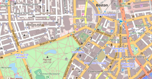
Example of OSM mapping- you can zoom out for a wider view as well

This is the first time that we have made a blog so we will need to update this as we go along- so far it appears that the tablet is up to this but we have invested in a bluetooth keyboard to make it easier (£11 off amazon and weighs less than 100g)

Continue Reading

Artwork

Producing the website is a new experience,  lots of trial and error with WordPress software.

One thing we needed was some artwork for a logo,  we planned to approach an artist friend but then Laura came to our party and when she heard about snailcycle she drew us a great picture and so with a bit of manipulation to make it suitable for the Web we now have original artwork of a snail sat on a saddle.

Thank you Laura

Lauras snailcycle artwork

Laura’s original artwork


Continue Reading

That looks a long way

Having perhaps rather rashly come up with the idea of extending the traditional Land End to John O’Groats route to include the Scilly and Shetland Isles  we have been working away looking at the route options- it is further than we thought!

Google plots a direct route of 1222 miles, ours will be a fair bit longer as we propose to weave around on smaller roads and also have some detours to visit friends on the way, probably the total will be 1300 to 1400 miles .

Map from google

Googles estimate

An extra incentive to do more cycling in the next few weeks

Continue Reading

Preparations- social media

There are things we  feel pretty knowledgeable about our trip- the cycling , camping, route planning and first aid etc, but one area we had little knowledge of at all- social media.

We have been putting together our website and blog but how to interact with Twitter and Facebook was a complete mystery – so we are immensely grateful to have some help from a real professional expert- the wonderful Louisa Clack from London PR  gave up her Sunday morning to share some of her professional expertise and walk us through how to get started.

Any successes in this feild are hers, any failures are clearly down to our lack of knowledge!

Continue Reading

Getting ready

We are starting to prepare for our end to end, tweaking the bikes,  renewing the worn out mudguards and more importantly doing plenty of cycling with our club the Chesterfield Spire cycling club. We are hoping to average 40 to 50 miles a day on our trip but this will be when we are carrying all our luggage,  we are currently doing about 50 miles a day without luggage and not every day so clearly have some more work to do

Continue Reading

What’s the plan?

map with titles


So what is the whole Snail Cycle project?

We are two doctors from Chesterfield in Derbyshire

We plan to cycle from the southernmost part of the British Isles (St Agnes on the Isles of Scilly) to the most Northerly inhabited point (Unst in the Shetlands) , unsupported and camping most of the time.

Why Snail Cycle?

Some people cycle from Lands End to John o’Groats in incredible times, this is usually done with a support team in a van or motorhome to carry their luggage, provide food and support and help with all the logistics.

We aim to do the opposite- we will carry our own tent and clothes (our house on our back) , not always take the straightest coarse as we will stick to quieter rural roads and will definitely not be the fastest

Continue Reading